
5 Backpacking Trips in Colorado That Don’t Require Permits

There are many popular trails in Colorado that require permits and they can be a pain in the butt to get if planning far in advance isn't your strength. However, being a spontaneous adventurer myself I've come up with a list of worthy backpacking destinations that don't require applying for a permit in advanced. It is strongly advised that you do fill out a self-issuing permit at the trailhead and drop it in the brown box. There are no quotas or fees with these and they will usually be right at the beginning of trailheads, wilderness boundaries, etc... Some have them on this list and some don't but if you see it fill them out! Doing so helps our forest service keep track of recreation usage so they can better manage visitation.
Now some things to note before we get into it...
None of these trips have designated campsites however, there are most definitely established campsites. What is the difference you ask? Well, a designated campsite is one which is numbered or labeled which a tent symbol indicating camping is only allowed at these sites. This is common in heavily visited wilderness areas but as of right now in 2022, none of the destinations on this blog post have designated camping. It is still STRONGLY encouraged to set up camp in an area that has CLEARLY been camped on already. Don't set up camp in fragile alpine tundra or on sensitive cryptobiotic soil in the desert. This destroys the environment and takes hundreds of years to bounce back from. See my post on LNT to learn more about traveling and camping on durable surfaces.
Please use your own discernment when considering which trips are appropriately matched to your skill level. I listed a variety to include beginner backpackers and advanced adventurers. Some are popular, shorter in length and straightforward. Others are longer and require a bit more experience with route finding.
#1 Mt. Zirkel Loop in Mt. Zirkel Wilderness
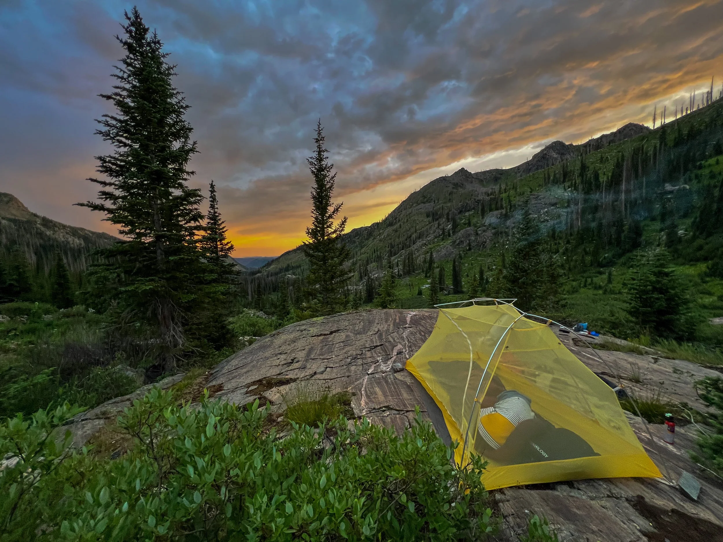
Tucked away in the northern region of Colorado, Mt. Zirkel Loop offers one of the most gorgeous backpacking loops in the state. This ~ 10-11 mile loop gains around 2,400 ft of elevation and weaves through the heart of Mt. Zirkel Wilderness. This remote area is surrounded by stunning wildflowers, meadows, alpine lakes, and an abundance of wildlife.
Starting at Slovenia Trailhead, you must decide which direction to head. I traveled counter clockwise on the Gold Creek Trail because I wanted to top out above Gilpin Lake and have that view descending into the valley below. It worked out great, Gold Creek Lake provided great camping for night 1.
From Gold Creek Lake, the trail starts to become steep as we begin gaining quite a bit of elevation to reach the top of the saddle at 10,400 ft. The 360 degree views from up here are absolutely incredible.
From here, you will descend into one of the most beautiful basins in the region. The icy blue water is surrounded by jagged granite peaks with plenty of campsites tucked into the forest surrounding the lake.
If the weather allows for it, there are campsites above the lake but be weary because you will be above treelike. Only camp here if you are certain there is no chance of thunderstorms.
This is an excellent beginner alpine trip. The trail is easy to follow and the raw nature offers you the best of everything you would want in a short 2 night backpacking trip— a quick escape into the kind of rugged beauty that resets your nervous system.
#2 Mill Castle Trail in Gunnison National Forest

This is truly a hidden gem that I stumbled upon during a solo 2020 pandemic road trip with my dog. I went in late May and was STUNNED by the lush new growth of Aspens everywhere.
The trail wasn't very maintained and there were a lot of downed trees. I recall having to be very careful about where I selected to pitch my tent to avoid standing dead trees. But WOW... it was such a unique area and as the name implies the geology very much made me feel like I was embarking upon some hidden secret castle. I saw 2 other hikers that whole trip.
I recommend this for a backpacker that has had quite a few trips under their belt and is comfortable using a map/compass and/or GPS. The path is fairly easy to follow, nevertheless because it isn't a popular area you should be ready to create a route plan and check your waypoints as you go.
If you are looking for an extreme adventure in an area with very few visitors- the Mill Castle Trail to Lowline Trail Loop should be high on your list! The length is about 22.5 miles total and sees just over 5600 ft in elevation gain. If you are an endurance runner I'm sure you could bang this out in a really long day but I recommend taking your time and doing it as a 2 night/ 3 day backpacking trip.
You'll start on the valley floor and will eventually have to cross over Mill Creek which could be tricky at higher water levels but it is doable. After that, the trail starts to gently climb through rolling hills of Aspen groves which are stunning late Spring and in Fall. 4 miles into your hike you will reach a stunning waterfall and just after this you will find a couple great areas to set up camp for the night. However, if you can muster up the energy to push another 1.3ish miles you will find another area suitable for camping and it will make your ascent up and over Storm Pass the next day much more tolerable. Summiting the pass will absolutely take your breath away and is arguably one of the best views in the entire state. You can see the castle formations, Elk Range Mountains and on a really clear day you can even see Pyramid Peak and Maroon Bells off in the distance.
Watch the weather and make sure you are up and over the pass before afternoon thunderstorms arrive. The completion of the loop is no less stunning but the descent will definitely take its toll on your body so be gentle with yourself and have those trekking poles ready to assist you on the way down.
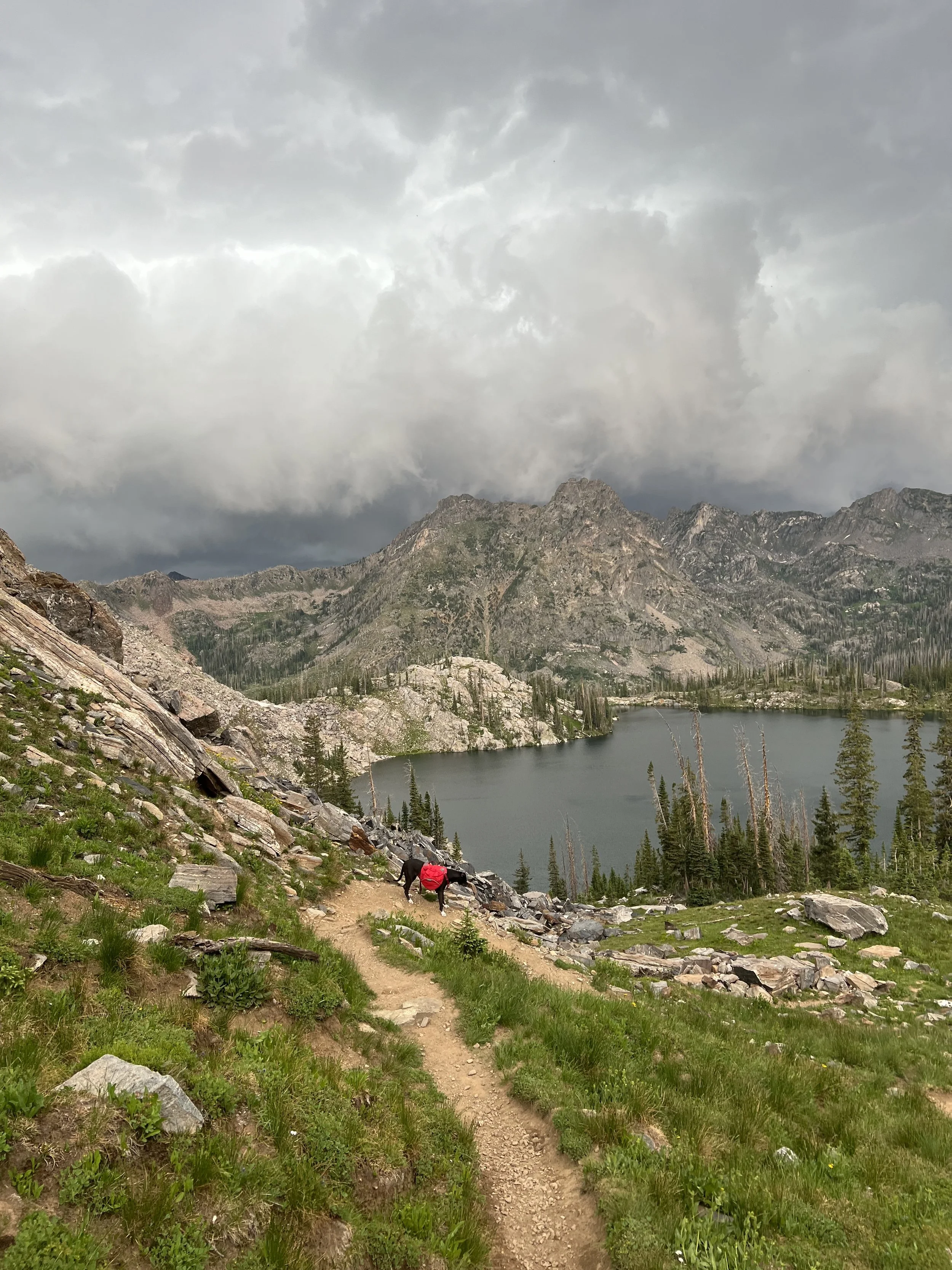
#3 Missouri Lakes Loop in Holy Cross Wilderness

This is one of the best loops under 10 miles in the state. Missouri Lakes/Fancy Lakes Loop is around 8.8 miles total.
It has everything you're looking for in a quick one night backpacking trip... forest, meadows, wildflowers, creeks, two mountain passes, marmots, alpine tundra, and TONS of stunning alpine lakes.
This can absolutely be accomplished in a day for strong hikers but you really get to soak it all in on a 1/2 night backpacking trip because come on, who wouldn't want to spend a night star gazing here! Just past Vail is a quaint mountain town called Minturn and just beyond Minturn is the Holy Cross Wilderness, notably named after the massive 14er Mount Holy Cross.
You can either start at Missouri Lakes Trailhead and hike clockwise ending at Fancy Lake Trailhead. Or the opposite counter-clockwise approach. The steepest part is going to be from Fancy Lake TH up and over the pass. Once you get over the pass it's a much more gentle descent down to Missouri Lakes. So start at Missouri Lake TH and have a brutal day 2 getting down a steep scree field. Or start at Fancy Lake TH and have a strenuous first day pushing yourself up two mountain passes but you can really relax and enjoy the rest of the hike finishing up the loop. I prefer the counter-clockwise approach because I want to avoid the shaky Elvis legs that I develop with steep descents especially with carrying all that weight on my back.

I would rate this as generally moderate terrain overall but it gets more of a difficult rating because of the two mountain passes (Missouri Pass ~11,986 ft and Fancy Pass ~12,390 ft) that you have to climb.
In between the passes you are hiking on top of the world in pristine Alpine Tundra. You can veer off to the west and hike to Treasure Vault lake for an additional 0.4 mile adventure.
There is approximately +2634 ft of elevation gain and -2659 ft of elevation loss. The lowest point is at the start 9,998 ft and the highest is at the top of Fancy Pass at around 12,390 ft. Make sure you are acclimated to hiking at high elevations and are drinking plenty of water and replenishing electrolytes!
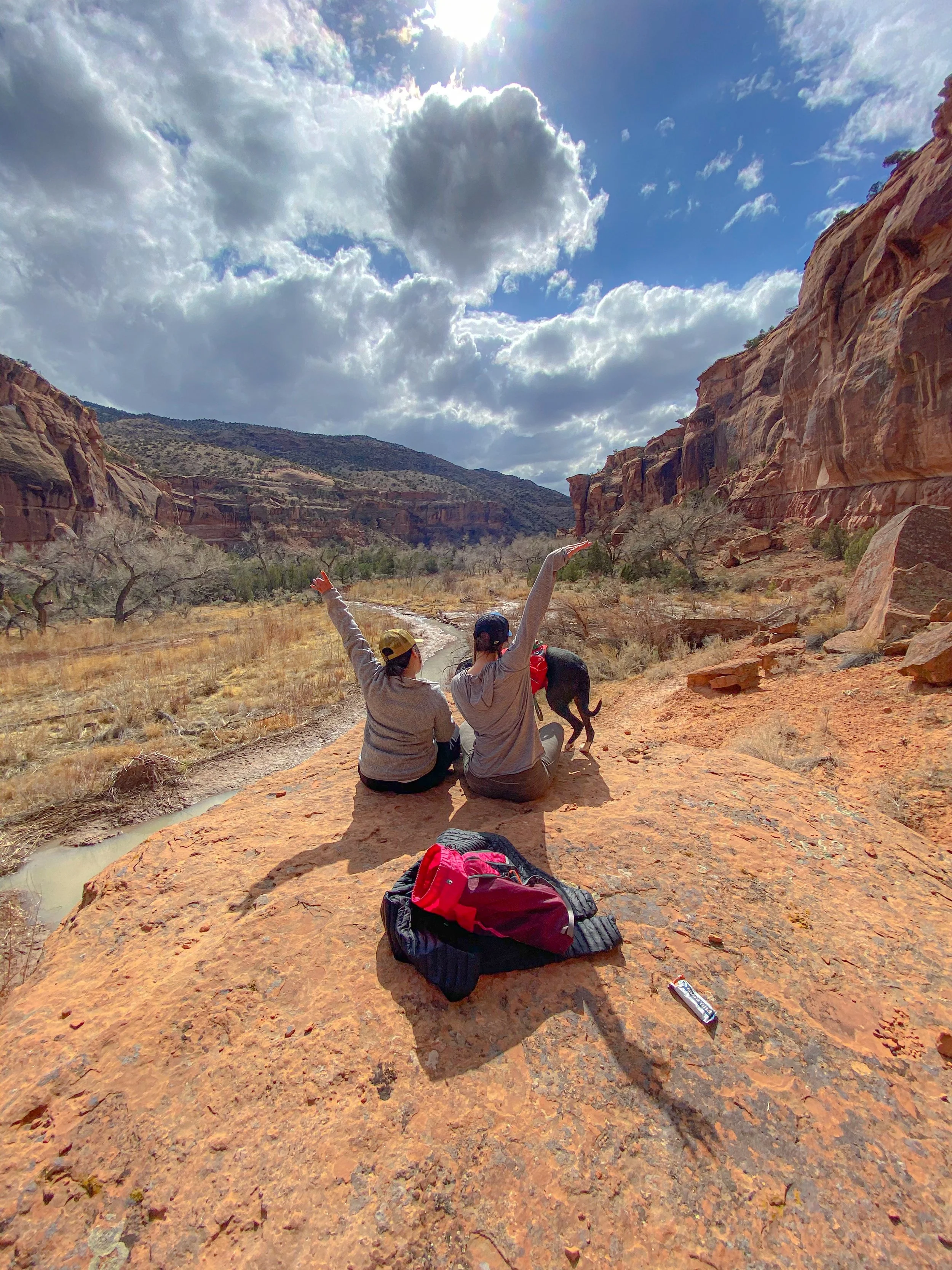
#4 Dominguez Canyon Wilderness

I know what you are thinking... "I thought we were talking about Colorado backpacking"... and we still are! This is not Utah or Arizona, this is still in the beautiful and diverse Colorado! Yes we are known for our beautiful alpine lakes and snow capped peaks but we also have desert environment too.
Dominguez Canyon Wilderness is about 30 minutes SW of Grand Junction. So if you are craving some desert life but don't feel like making the drive all the way to Utah, this area is an absolute hidden gem.
I backpacked here last year for my birthday in March. It was dry, sunny, highs of 50s during the day and lows of around 30 at night. A few days before our trip it did snow in this area so you want to keep an eye on the forecast if you are contemplating an early Spring backpacking trip here but it's totally doable!
The route is pretty straightforward starting at the Bridgeport Trailhead you will go through a green gate and then walk along side old railroad tracks until you cross over the tracks to an old townsite. After about a mile of hiking you will pass the first bridge which is private property and then at the second bridge you will see a trail kiosk to register at. After signing in, cross the bridge over the Gunnison River and continue on the trail. At around mile 2.5 you'll reach the junction of both canyons- Big Dominguez Canyon to the right and Little Dominguez Canyon on the left.
This trip can be done as a ~35 mile loop going up Big Dominguez and connecting to Little Dominguez to make your way back. There is an area within both canyons to start where camping is prohibited but these boundaries are clearly indicated. One you pass those boundaries you are free to camp wherever (of course using best wilderness practices.)
There is also about a 7 mile stretch in Big Dominguez Canyon with no water source. Plan ahead and prepare for this!
Map and compass skills are highly necessary if you want to complete this loop. Descending down into Little Dominguez Canyon shows no obvious trail so so down climbing and route finding is required as it is minimally traveled. The terrain becomes pretty technical in this area so if you're not comfortable with that quite yet you could always do an out and back in Big Dominguez Canyon.
This area features red canyon walls, cactus, waterfalls, old settlements, ancient petroglyphs and the largest concentration of desert bighorn sheep in Colorado. It is one of the most unique areas in Colorado and is managed by BLM in the Dominguez-Escalante National Conservation Area. I recommend visiting this area in Spring or Fall because Summer temperatures can be brutal.
#5 Goose Creek Trail in Lost Creek Wilderness
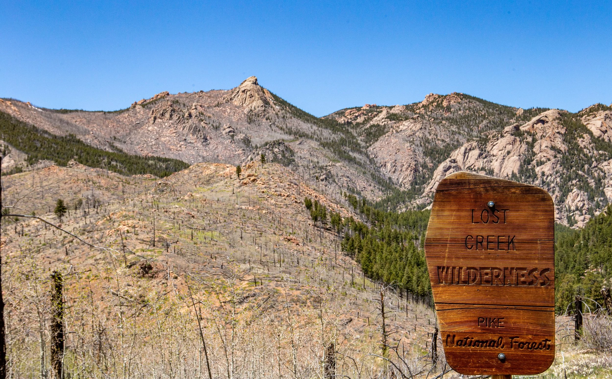
As soon as you start to drive into Lost Creek Wilderness you will notice one distinguishable thing and that's fire damage. It may seem like it's never going to end but you will indeed reach forest once again. This area is rich in giant granite formations, lush forest, beautiful meadows and is home to both the Kenosha and Tarryall Mountain Ranges.

Goose Creek Trail 612 to McCurdy Trail is a 12.6 miles out and back hike. This is great for beginners that are wanting to test out their new gear and get their first overnight checked off the list. The trail is relatively easy to follow and campsites are plentiful as is water. There are lots off mosquitos in the area given the close proximity to the creek so be prepared with a head net and insect repellent!
This trail is also a great option for experienced backpackers who want to put in more miles because you can make this a ~24 mile loop. Many of the trails in this area intersect offering various different routes and adventures. I encourage you to buy a USGS map of the area and start planning!